M/C Anahi Catamaran Yacht

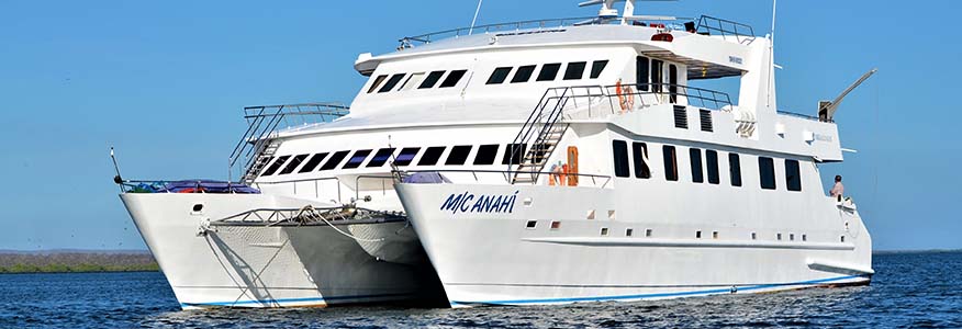
M/C Anahi Catamaran Yacht
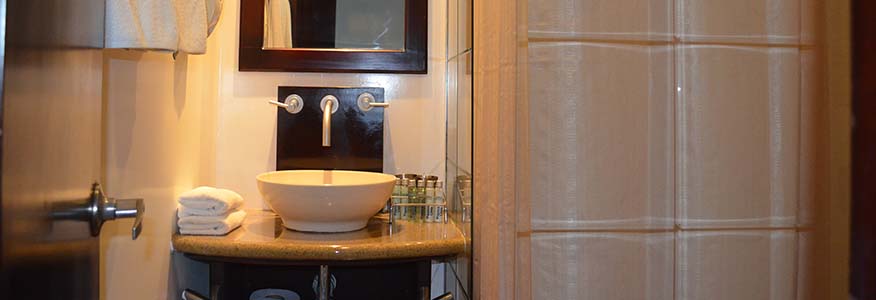
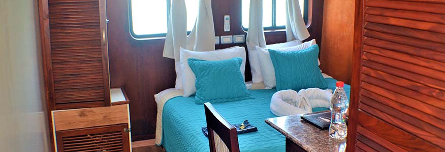
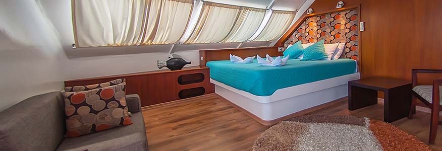
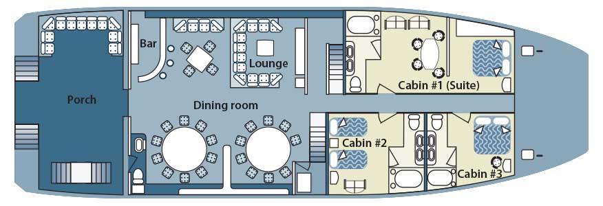
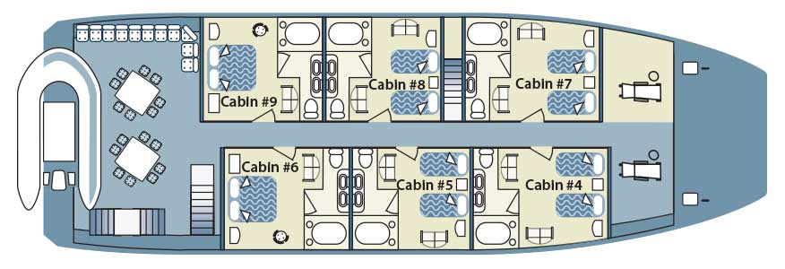
The accommodation for sixteen voyagers is distributed amongst six 14m2 twin cabins on the main deck (2 transformable to double bed), and two 25m2 suite cabins on the upper deck. Every cabin includes large windows - portrait type - looking to the ocean, beautiful wooden floor and cozy private facilities with hot/cold water shower, besides to a locker, closet and air conditioning.
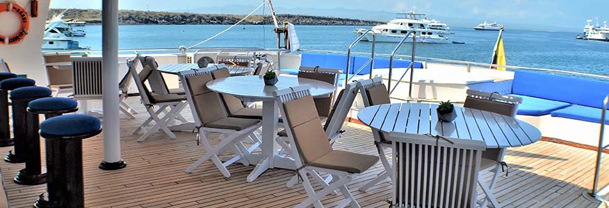
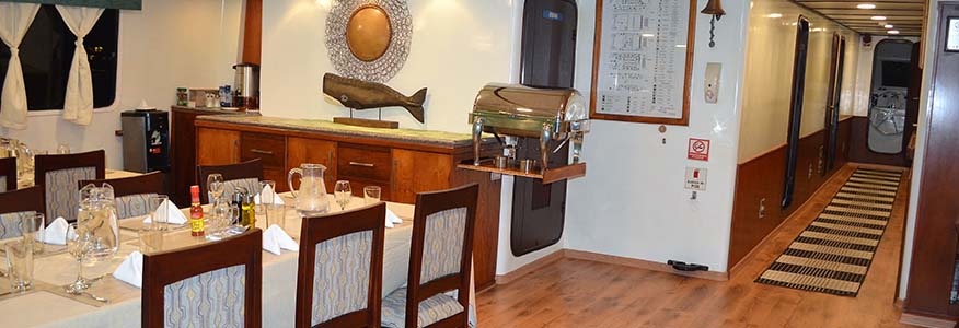
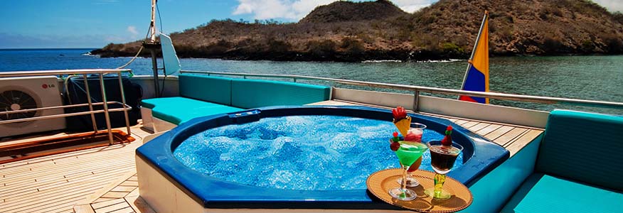
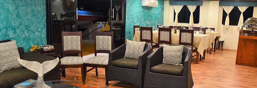
Additionally, on the main deck, the yacht offers ample resting areas, library, TV-DVD room, comfortable dining room and lounge. On the upper deck, the yacht features a charming bar and an excellent area for relaxation, together with a Jacuzzi for six people. On top of the bar area we find the ample sundeck with resting chairs for eight people.
- Day 1: Tuesday
am
Arrival at San Cristobal Island. Transfer to the yacht.
pm
San Cristóbal: Visit Interpretation Center & Tijeretas Hill
- Day 2: Wednesday
am
Española: Visit Punta Suarez
pm
Española: Visit Gardner Bay
- Day 3: Thursday
am
Floreana: Visit Punta Cormorant / Corona del Diablo.
pm
Floreana: Visit Post Office Bay
- Day 4: Friday
pm
Visit to the Charles Darwin Station and transfer to the airport in Baltra for your flight back to Quito or Guayaquil.
- Day 1: Friday
am
Arrival at Baltra airport. Transfer and aboard the Yacht.
pm
Visit Bachas Beach.
- Day2: Saturday
am
Genovesa: Visit Darwin Bay
pm
Genovesa: Visit El Barranco
- Day 3: Sunday
am
Visit South Plazas Island
pm
Visit Santa Fe Island
- Day 4: Monday
am
San Cristóbal: Visit Punta Pitt
pm
San Cristóbal: Visit Leon Dormido and Lobos Island
- Day 5: Tuesday
am
San Cristóbal:Galapagos Turtles Breading Center of Cerro Colorado. Transfer to the airport for your flight back to Quito or Guayaquil.
- Day 1: Friday (SANTA CRUZ ISLAND. HIGHLANDS)
Upon arrival at Baltra Island airport (from Quito or Galapagos, travelers pass through an airport inspection point to insure that no foreign plants or animals are introduced to the islands.
After clearing the entrance to the national park, our guide will meet you at the lobby, collect your luggage, and escort you on the short (15 minutes) bus ride to the Itabaca Channel. After crossing the canal using a
small ferry, we will board our bus for a 45 min / 1-hour drive towards the small city of Puerto Ayora.
From the pier of the town, motorized zodiacs (called ‘Pangas’) will transport you aboard the M/C Yacht
Catamaran ANAHI. Once on board, our crew welcomes you with a refreshing drink and after being
accommodated in your cabins you are invited for lunch and after a short rest.
At about 2 p.m. you will be transported to the highlands of Santa Cruz Island, up to a private farm
where you will enjoy your first visit to the Galapagos Islands. Our guide will take you for a nice walk
among the beautiful trees of the forest including ferns and sedges, miconias, etc. Here you will be
amazed with the giant tortoises that roam freely in the farm, their natural habitat. The Tortoises are
very shy, and will typically withdraw into their shells as soon as they see you coming close. It is very
important not to bother, touch or feed these beautiful animals. The area also contains several species
of birds including the famous Darwin finches, the rare “Pájaro Brujo” (Wizard Bird) with it’s beautiful
red coloration, and many more. At this place we also find a simple but nice structure where you can
rest and buy drinks, beers or a try delicious local fruit juices and snacks. Later on you’ll head to one of
the many lava tunnels existing in the area. Here you enjoy of a short hike into the tunnel, where one
can admire the amazing results of powerful volcanic eruptions occurred some 5 million years ago that
shaped the islands we know now. We’ll head back to Puerto Ayora and to the yacht after this visit
point, and at 7 p.m. you will have the official welcome drink followed by dinner. After dinner The guide
will explain about the next day’s activities as well as some general recommendations for travelers in
the Galapagos islands
Lunch, Dinner included.
- Day 2: Saturday (ISABELA ISLAND. PUERTO VILLAMIL & SIERRA NEGRA VOLCANO)
Isabela Island is the largest and youngest islands in the Galapagos archipelago. From Puerto Ayora the
navigation towards Isabela will start at about 1 a.m. arriving at about 6 a.m.to the port of Puerto
Villamil. At 6:30 a.m. you will be awaked up by the guide and breakfast will be ready at 7:30 a.m.
At the morning, we start our first visit to the islets known as Las Tintoreras. Access to this location is
easy where visitors can land during high or low tide to this beautiful visitor site located south of Puerto
Villamil. It has a small bay of completely calm turquoise waters, where you can appreciate sea lions,
sea turtles, marine iguanas, rays and many more species of Oceanside fauna and flora. The bay is
connected to a shallow crevice of crystal clear water which closes when the tide is low, and is a
favorite resting spot for sharks and fish life. Most of the trail in this visit point is “Ah Ah” Type Lava,
except for a white sand beach and a black stone beach. The first beach we will encounter is popular
with sea lions that are found sleeping peacefully, as well as marine iguanas that nest in the area. You
can also see some Nolana galapageia plants, a rare endemic plant in the area not common in Ecuador,
since this species is typical of continental coastal zones and belongs to a genus whose distribution is
restricted to Chile and Peru.
The second beach is entirely surrounded by button mangrove (Conocarpus erecta) and white
mangrove (Laguncularia racemosa). Throughout the trail you can see many marine iguanas in the rocks
or under the mangroves
Las Tintoreras is one of the few places where the iguanas breed successfully because of the absence of
non-native animals that could kill the new born reptiles. Various parts of Las Tintoreras are ideal for
nesting marine iguanas. During nesting season be very careful when exploring the area. Reef sharks
(here known as Tintoreras) have nocturnal feeding habits and certain individuals remain inside the
crevice and marine ponds during the day to rest. For this reason, you are not allowed to swim in this
place. We’ll head back to the yacht for lunch and relaxing.
After the visit to Tintoreras, you disembark to Puerto Villamil to head up to the highlands of the Sierra
Negra Volcano that is a large shield-type volcano located at the South eastern end of Isabela
Island and it rises to an altitude of 1124m. It sits between with the volcanoes Cerro Azul to the west
and Alcedo to the north. It is also one of the most active of the Galapagos volcanoes with the most
recent historic eruption in October 2005.
Our guided tour of the volcano starts at Puerto Villamil with a car drive of about 30 minutes to where
we start our 1 hour walk towards the rim of the giant caldera along its East side. The view is really
amazing and impressive since the caldera, with dimensions of 7.2 x 9.3 kms, is considered the 2nd
biggest crater in the world (after the Ngorongoro crater in Tanzania). From the several viewpoints
located along the rim of the crater we can observe down inside of the crater the recent lava flow of the
2005 volcanic eruption. After another 2 hours hike from the rim of the Sierra Negra crater, the area
known as Volcan Chico is located, an interesting sight where it is possible to observe some fumes, and
explore this Martian-like landscape. From here we can also observe the faraway volcanoes of Isabela
Island. This last visit is recommended for those tourists with good physical conditions and depends on
the group.
After we take lunch, we will visit the area known as The Wetlands where you can see a variety of
endemic wetland birds.
Then of this visit we will have a free time in the small town of Puerto Villamil. We aboard the yacht for
a well-deserved dinner and rest. Breakfast, Lunch, Dinner.
Note: depending on the weather conditions, itineraries on this day can be modified.
- Day 3: Sunday (ISABELA ISLAND: PUNTA MORENO & ELIZABETH BAY)
Punta Moreno is located on the north coast of Isabela Island between the volcanos Sierra Negra and
Cerro Azul. The distance of the trail is about 2100 meters and runs along a lava flow of “Pahohoe” type
lava (solidified lava in the form of corrugated cardboard or an accordion) into a complex of coastal
lagoons. The vegetation found in the area is small and concentrated mainly in the mangrove area and
around the lakes. It should be noted that the three kinds of cacti are found here amid black lava flows
where there are several species of interesting birds. Here we also find a panoramic view of the three
most active volcanoes of the Galapagos: are Sierra Negra, Cerro Azul both of Isabela Island and La
Cumbre of Fernandina Island. Unfortunately, until the 1970’s a population of wild dogs that existed on
this site fed on marine iguanas, sea lions and other marine species and drank the abundant brackish
water present here, but are now eradicated. After this visit we return to the boat for lunch and a short
rest before heading into our afternoon activity.
Special Indications:
Do not frighten the Flamingos. They are sensitive to noise and get scared easily. Stay within the group.
The road to the large lagoon is long and dangerous, where you have to cross 700m of broken lava,
making it somewhat difficult to walk. Wear comfortable and appropriate shoes for this type of
hike. Due to high temperatures and strong sunshine, especially during the hot season (December to
May), it is better to take the activity in the early hours of the day or late afternoon due to type of
terrain.
Since there is no landing point at Elizabeth Bay, this excursion is carried out in a zodiac., this excursion
starts into the cove that is surrounded by red mangroves where you can admire their red roots and
green leafs. It is here that you are able to observe sea turtles, flightless cormorants, spotted eagle rays,
golden rays, brown pelicans, and sea lions. Frequently visitors have been able to see Galapagos hawks
soaring overhead while schools of Pompano and Dorado fish swim below. This site is really amazing
due to the high quantity of land and marine wildlife as well as the unique and beautiful landscapes.
We’ll return to the yacht for dinner and rest
Breakfast, Lunch, Dinner.
- Day 4: Monday ( ISABELA ISLAND: URBINA BAY & TAGUS COVE)
This walking visitor site is located at the east base of the Alcedo volcano. The trail has an approximate
distance of 3200m, and starts on the beach where a wet landing is made, and runs through sand, rock,
lava, coral and vegetable formations in a coastal area. This area is considered amongst the best
showcases of the geological formations of the islands as many aspects of the creation of the
archipelago can be seen. The waters of the bay are a good place to see turtles and rays, as well as head
into a short trail leading to a coral reef above the surface of the water, evidence of uplift from the sea
which occurred in 1954.
From here it is easy to reach the Alcedo and Darwin volcanoes. Here you can see large, colored land
iguanas, as well as giant Galapagos turtles, flightless cormorants, blue-footed boobies, Galapagos
penguins, pelicans, and marine iguanas
Special Indications:
- Protect your camera equipment well as the landing can be problematic due to the strong waves that occur often on this site.
- Bring water for the hike as the trail is long and the place is very hot.
- Do not take pieces of coral. Corals exposed to air will deteriorate quickly and should not be touched.
We will return to the yacht to enjoy a delicious lunch, followed by a short navigation to Tagus Cove. A
tour along the cliffs in a zodiac will give the visitors a good chance to see the Galapagos penguin, the
flightless cormorant and other sea birds. From the landing dock a 30-minute hike along the trail up to
the top of the cliff takes you to a viewpoint of Darwin Lake, an uplifted ultra-saline lake. You can also
see several volcanoes from this location. The route of the trail is about 1800 meters, and was
considered a favorite spot for pirates and whalers, a tradition continued with the names of boats and
ports. At the start of the walk, we find a small cave where we find inscriptions dating to the 1800s. The
trail is mostly gravel, and leads into the interior of the island along Darwin Lake. During the walk, you
can see various land birds and identify the characteristic vegetation of the arid zone.
Finally, we observe the lava fields of Darwin Volcano. Darwin Lake rests upon a “tuff” type cone, contains
saltwater and its depth is approximately 9m. It has no fish and few forms of life due to its high salinity.
Explosive volcanic eruptions must have occurred at the site, as the substrate has a large amount of
volcanic rocks of different sizes, among the most common are little balls of nearly perfect spherical shape
known as the "lapilli" or petrified rain.
Breakfast, Lunch, Dinner.
Special Indications:
- Take care when landing due to strong waves.
- Apart from the ground path, a panga ride is very interesting and entertaining. The panga should keep its distance from birds, especially penguins who are easily frightened.
- During the rainy season this site offers a great attraction for those interested in the vegetation, as the levels of humidity increase the plant life of the area.
- Day 5: Tuesday - FERNANDINA (ESPINOZA POINT) – ISABELA (VICENTE ROCA POINT))
Fernandina is the third largest island in the archipelago and has a single visitor site. Espinoza Point is
located at the northeastern tip of the island, and is a narrow ledge of lava and sand that extends from the
base of the volcano to the sea. The last recorded eruption of the island, occurred in May 2005 and lasted
three days. The greatest recorded explosive eruption was in 1968, where two thirds of the caldera floor
collapsed inwards to a depth of 300m.
In 1989 the last two land iguanas that inhabited this area died of starvation, and it is believed that
these two animals came down from the flanks of the volcano, where they are numerous.
Espinoza Point is a place famous for its large colonies of marine iguanas and as the habitat of unique
species like the flightless cormorant, Galapagos penguin, Galapagos hawk, Galapagos snake, among
others, as well as an ideal place to observe the lava cactus (Brachycerus nesioticus), which grows on
young lava and can survive with little water. After this visit, is possible to snorkel in the area, where
you can swim with marine iguanas, and large colonies of sea turtles, and if we are lucky, the beautiful
seahorses.
-
Special Indications:
- Fernandina is the only island, which has no introduced mammals. Be careful not to introduce organisms or take food of any kind. The area open to visitors is very fragile, stay on the trail at all times.
- At the nesting season for marine iguanas (January to June) it’s important that one be careful not to step on their nests (holes in the sand). These reptiles nest in the sand and sometimes cover the entire area.
- Stay within 2m of the cormorants and penguins.
- Land when the tide is high, if the tide is low you cannot use the dock, you have to land on the rocks.
Locals believe that Isabela Island has the shape of a sea horse, where is Vicente Roca Point is located
at the mouth of the animal. Here the remains of an ancient volcano form two turquoise coves with a
well-protected bay from the ocean swells.
From here, we take panga rides along the cliff to observe the remains of the volcano or explore a
partially sunken cave at the water’s edge. Masked and blue-footed boobies sit perched along the point
and the sheer cliffs, while flightless cormorants inhabit the shoreline. You can also see the fur sea
lions, the incredible mammals very similar to the curious Galapagos sea lions.
The upwelling of cold-water currents in this part of the Galapagos, give rise to an abundance of marine
life which, in combination with the protection of the coves, make Vicente Roca Point, one of the
archipelago’s most coveted diving spots. The entire area of Punta Vicente Roca lies on the flank of the
790 m (2,592 ft) high Volcano Ecuador, the Island’s sixth largest volcano. At the end of our activity in
the area, we will begin navigation, which will cross the equatorial line. At this point, we will have a
special cocktail to celebrate the crossing to the northern hemisphere.
Breakfast, Lunch, Dinner.
- Day 6: Wednesday (SANTIAGO ISLAND & RABIDA ISLAND)
The visitor site Egas Port is a black sand beach located on the west side of James Bay, northwest of
Santiago Island. South of the beach is Sugarloaf Volcano, which has deposits of volcanic tuff, the same
that has favored the formation of the black sand beaches across the archipelago. El Crater is just north
of this site; and has a saltwater lagoon, which during the summer dry season becomes a salt mine
which was attempted first between 1928 and 1930 to no major success, followed by a new attempt in
1964 which lasted for a longer period. These entrepreneurial attempts caused environmental damage
due to the usage of native and endemic wood firewood and the introduction of invasive plants and
animals.
This site is called Puerto Egas, after Mr. Hector Egas who attempted to exploit salt here and failed due
to the price of salt in other areas of the country. The walk along the rugged shoreline, especially at low
tide, will allow us to observe many marine species as Iguanas bask on the rocks and sea lions laying in
the tide pools. At the end of the trail there is a series of grottoes or sea caves where fur seals and night
herons are regularly found resting on the shady ledges.
You have the opportunity to snorkel from the beach of Puerto Egas, to enjoy the seascape relatively
different from what we have seen in previous days.
-
Special Indications:
- It is not permitted to go down into the crater of the salt mine. Lagoon birds nest there and resent any intrusion
- The Sugar Loaf is not a visiting area as there are dangers of falls.
- The beach area is open, but we ask you to avoid bothering the wildlife in the area.
- Do not leave the trail, avoid lud noises and sudden movements as this will bother the flamingo population.
- Rabida has many ravines and shrubbery that provides good nesting and resting places for a variety of seabirds as well as a suitable home for a small colony of fur seals.
- It is prohibited to climb to the summit. Lava flows from this island are extremely fragile and easily eroded
- Sombrero Chino is separated from Santiago Island by a small channel of turquoise waters. The adjacent lava flow on Santiago Island, is not visiting area.
- It is very nice to snorkel near the Shore of Santiago Island, where there are a variety of marine species.
- Stay within the paths. The geological features and soils here are very delicate. Due to wear caused by use, the GNPS has built stairs to avoid further erosion and better manage visitors.
- Atop of the island sits a marine lighthouse that covers a lava fume that could collapse under its weight if climbed upon.
- Do not get too close to penguins when they are resting on the ground because it can alter their natural behavior. It is better to see them and photograph them from the panga. Please stay in the beach area.
- When you are climbing to the summit and there is more than one group, please maintain a suitable distance so to avoid overcrowding the summit area.
- The frigates here are surly and it’s preferable to keep some distance from the nests. Do not let visitors leave the trail for a closer look at these birds, especially in the breeding season.
- Sometimes blue-footed boobies and swallow-tailed gulls nest along the path and walking slowly is required to avoid disturbing them.
In the afternoon we will visit Rabida Island, unique due to the red color of the rocks and sand. The
volcanic material in this island is very porous and external factors such as rain, salt water, and sea
breeze have acted as an oxidizing agent. Upon arrival we will enjoy a snorkeling activity, to learn about
marine life in this area with interesting species.
Later we will visit the terrestrial visit site that is located on the east coast of Rabida Island, consisting of
a red sand beach, a coastal lagoon behind the beach, and a loop trail. The approximate distance of the
trail is 1.1 kilometers. A short walk along a trail will lead you to the lagoon to observe the beautiful
land birds such as finches, doves, yellow warblers, and mocking birds. This lagoon is also a colony of
Flamingos. The red sand beach, along with the animals, lagoons and vegetation make this a great visit
spot!
-
Special Indications:
Breakfast, Lunch, Dinner.
- Day 7: Thursday (CHINESE HAT & BARTOLOME ISLANDS)
After a nightly short navigation, you will dawn in the beautiful Chinese Hat Chanel. This small islet is
located near the south-east coast of Santiago, and has been nicknamed according to its unusual shape
akin to a Chinese Hat when seen from afar. Through observation and study of the island, it has been
concluded that the lava flows near to its shoreline were formed under the sea and have been raised
upward, which is why coral heads are found on the lava.This visit provides an excellent opportunity for
the interpretation of geological features such as lava tubes and lava flows. The landscape is covered by
sea lion colonies, marine iguanas, and Galapagos penguins.
The trail is 700 m (round trip) and the minimum time it takes this trek is half an hour at a moderate
pace. You will swim on this wonderful bay with sharks, stingrays, fishes, and occasionally penguins,
before to return to the yacht to enjoy a delicious barbecue on the Yacht´s Upper Deck. Also, we could
explore the area in Kayaks visiting the interesting geological formations from the surface.
-
Special Indications:
Bartolome is one of the most famous points in the Galapagos, located across from Sullivan Bay near to
Santiago Island.
Arriving to this special site, we have the opportunity to swim around a pinnacle, and between rocks
that salen to the surface forming amazing sea life labyrinths. first of the two main visitor sites provide
the possibility to climb to the summit of the island,
Later, we visit the summit of the island, from where visitors can observe a variety of volcanic
formations including lava bombs, spatter and cinder cones, lava flows, and lava tubes. The moon like
landscape provides one of the most scenic panoramas in the archipelago.
At the second site, visitors have the chance to relax on a beautiful beach, which offers great snorkeling
opportunities. Multi –colored fish and occasionally penguins and sea turtles have been seen at the
base of the tall pinnacle rock, which dominates Bartolome’s landscape.
-
Special Indications:
- Day 8: Friday (SEYMOUR)
North Seymour is located north of Baltra, our last visit in this itinerary aboard of Anahi Yacht, where
the total distance of the trail is 3.5 km (2 miles).
In 1932 and 1933, about 72 land iguanas from Baltra were introduced to North Seymour by Captain
Alan Hancock and his crew with the intention that these animals could survive in better conditions
than in Baltra, already populated by goats. The iguanas that the crew of Valero III (Hancock's ship)
taken from Baltra were undernourished and after the introduction into North Seymour in 1934 it was
discovered that the iguanas had colonized the island without problems.
Later, during the Second World War when the United States occupied Baltra to install a military base,
the land iguanas disappeared slowly as their habitat was altered for the construction of runways and
barracks for soldiers and the invasive presence of goats, dogs and cats. By the end of 2008, 600 iguanas
have been accounted for on North Seymour, of which 400 have been repatriated and 200 were born in
the wild. Nowadays, with the eradication of introduced species in Baltra, we can find the population of
the largest land iguanas in the archipelago, and with a very good area for its reproduction. The main
vegetation bushy and low, hosting the largest nesting colony of Great Frigate birds in Galapagos.
-
Special Indications:
GROSS RATES |
4D/3N | 5D/4N | 8D/7N |
|---|---|---|---|
| Standard Cabin | $2,260 |
$2,785 |
$4,445 |
| Suite Cabin | $2,365 |
$2,950 |
$4,710 |
| Charter | $34,125 |
$42,660 |
$68,250 |
GROSS RATES |
11D/10N | 12D/11N | 15D/14N |
|---|---|---|---|
| Standard Cabin | $6,115 |
$6,665 |
$8,335 |
| Suite Cabin | $6,480 |
$7,070 |
$8,835 |
| Charter | $93,845 |
$102,375 |
$127,970 |
Main Deck
Upper Deck
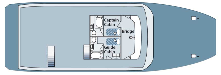
Master Deck
Specifications
| Type: |
|
| Category: |
|
| Year: |
|
| Lenght: |
|
| Beam: |
|
| Capacity: |
|
| Main Engines: |
|
| Electric System: |
|
| Speed: |
|
| Water Capacity: |
|
| Diesel Capacity: |
|
| Material Construction: |
|
| Interiors: |
|
| Exterior: |
|
| Crew: |
|
| Navigation & Safety Equipment: |
|
| Accommodation: |
|

